library(tidyverse)

# Get station data for all stations in TX and LA
TXLA_stations <- read_fwf("https://www1.ncdc.noaa.gov/pub/data/ghcn/daily/ghcnd-stations.txt",
    fwf_cols(
      STATION = c(1, 11),
      LATITUDE = c(13, 20),
      LONGITUDE = c(22,30),
      ELEVATION = c(32,37),
      STATE = c(39,40),
      NAME = c(42,71),
      GSN_FLAG = c(73,75),
      HCNCRN_FLAG = c(77, 79),
      WMO_ID = c(81,85)
    )
  ) %>%
filter(STATE %in% c("TX", "LA"))3 Precipitation
3.1 Data Procurement
- Data was downloaded from the NOAA Global Historical Climatology Network daily FTP server.
- ZCTA to County Crosswalk was downloaded from https://www2.census.gov/geo/docs/maps-data/data/rel/zcta_county_rel_10.txt
- ZCTA shapefiles were downloaded for the entire US using the
tigrispackage
Documentation for the dataset can be found here
3.2 Data Processing
NOAA Climate Data is collected at the station level, so the primary function of this processing is to impute the precipitation for the ZCTA
- Station metadata was downloaded from the NOAA Global Historical Climatology Network daily FTP server and limited to TX and LA
- Station measurement data was downloaded from the NOAA Global Historical Climatology Network daily FTP server and filtered to those included in the metadata downloaded in step 1 without quality flags
- 2017 ZCTAs downloaded from the US Census Cartographic Boundary Files
- Then, the ZCTAs were joined to the UDS Mapper Zip Code to ZCTA Crosswalk in order to identify Texas and Louisiana ZCTAs
- The ZCTAs were filtered to Texas and Louisiana
- The
gstatpackage was used to predict inverse distance weighted predictions of precipitation at the zcta level- Cross validation was preformed (not shown) and optimal hyperparameters idp = 0.5 and nmax = 8 were identified
3.3 Output
TXLA_ZCTA_PRCPpred- GEOID - ZCTA GEOID
- DATE - Date (YYYY-MM-DD)
- PRCPpred - Inverse Distance Weighted Daily Precipitation (tenth of mm)
3.4 Code
Downloaded station information
Downloaded the station data that is within TX and LA, in August and September 2017, and has no quality assurance flags.
TXLA_station_data <- read_csv("https://www.ncei.noaa.gov/pub/data/ghcn/daily/by_year/2017.csv.gz",
    col_names = c("STATION", "DATE", "VAR", "VAL", "M_FLAG", "Q_FLAG", "S_FLAG"),
    col_types = cols_only(
        STATION = col_character(),
        DATE = col_date(format = "%Y%m%d"),
        VAR = col_character(),
        VAL = col_double(),
        VAR = col_character(),
        M_FLAG = col_character(),
        Q_FLAG = col_character(),
        S_FLAG = col_character(),
    ),
    lazy = TRUE) %>%
  filter(STATION %in% TXLA_stations$STATION) %>%
  filter(DATE %within% interval(ym("2017-08"), ym("2017-10")-1)) %>%
  filter(is.na(Q_FLAG)) %>% # remove failed quality check measurements
  pivot_wider(
    id_cols = c(STATION, DATE),
    id_expand = TRUE,
    names_from = VAR,
    values_from = VAL)
Spatially joined stations to ZCTAs
library(sf)
library(tigris)
options(tigris_use_cache = TRUE)

ZCTAs <- read_csv("https://www2.census.gov/geo/docs/maps-data/data/rel/zcta_county_rel_10.txt") %>%
  filter(STATE %in% c(48, 22)) %>%
  distinct(ZCTA5) %>%
  rename(GEOID = ZCTA5)

ZCTAs_sf <- ZCTAs %>%
  left_join(zctas(cb = FALSE, year = 2017), by = join_by(GEOID == GEOID10)) %>%
  st_as_sf() %>%
  select(-c(ZCTA5CE10, CLASSFP10, MTFCC10, FUNCSTAT10, ALAND10, AWATER10, INTPTLAT10, INTPTLON10))

TXLA_stations_sf <- TXLA_stations %>%
  st_as_sf(coords = c("LONGITUDE", "LATITUDE"), crs = 4326) %>%
  st_transform(crs = st_crs(ZCTAs_sf))
Conducted inverse distance weighted imputation for the ZCTA
library(gstat)
library(furrr)
library(progressr)
plan(multisession, workers = 12)
with_progress({
p <- progressor(steps = length(unique(TXLA_station_data$DATE)))
TXLA_idw_preds <- unique(TXLA_station_data$DATE) %>% future_map(~
TXLA_station_data %>%
left_join(select(TXLA_stations_sf, STATION)) %>%
filter(DATE == .x) %>%
st_as_sf() %>%
drop_na(PRCP) %>%
gstat(data = ., formula = PRCP ~ 1, nmax = 8, set = list(idp = 0.5)) %>%
predict(ZCTAs_sf) %>%
st_drop_geometry() %>%
select(var1.pred) %>%
rename(PRCPpred = var1.pred) %>%
bind_cols(ZCTAs_sf, DATE = as_date(.x), .) %>%
as_tibble() %>%
st_as_sf()) %>%
do.call(bind_rows, .)
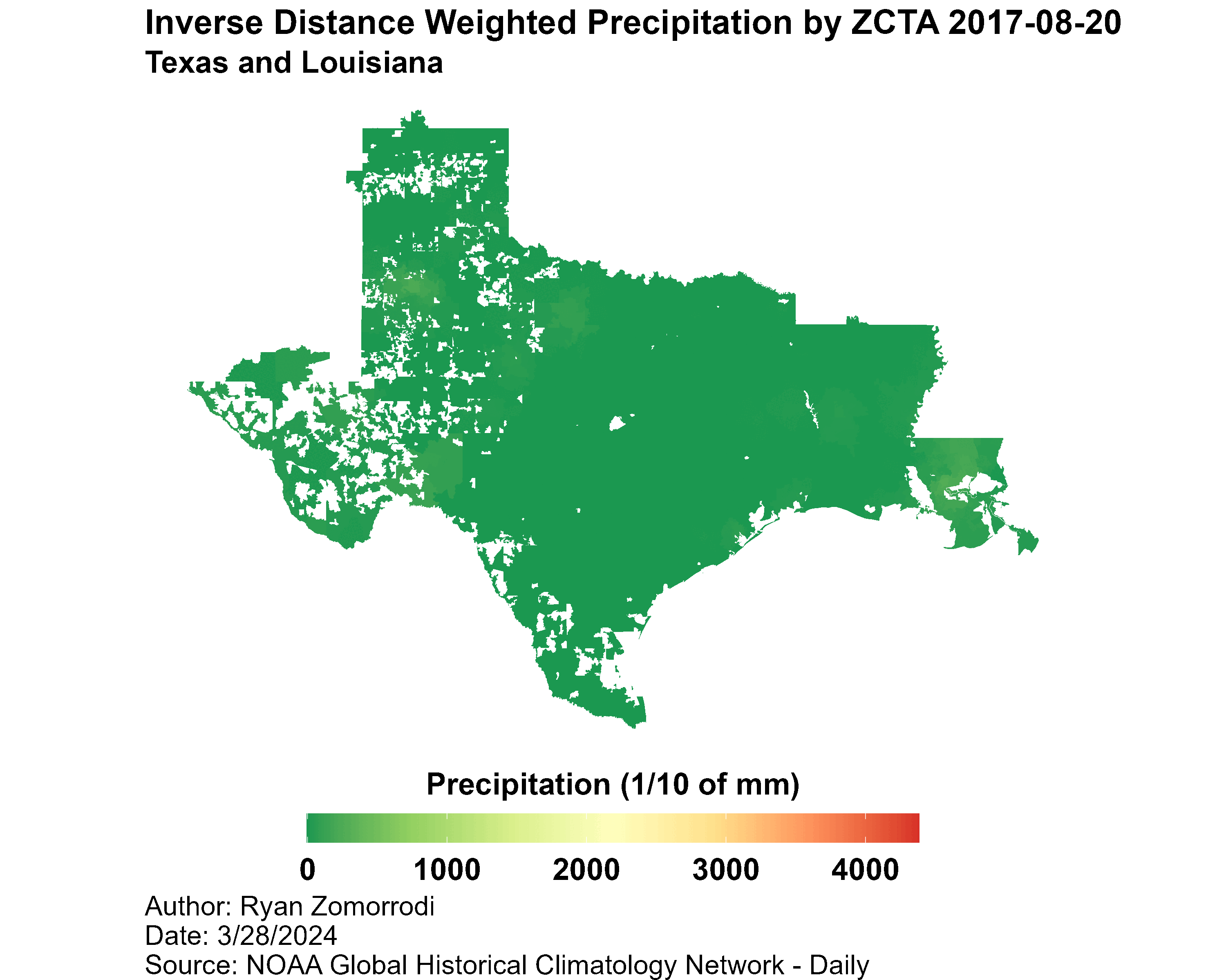
}) Created individual plots for each day
max <- TXLA_idw_preds %>%
  st_drop_geometry() %>%
  summarize(max = max(PRCPpred)) %>%
  as.integer()

plots <- unique(TXLA_station_data$DATE) %>% map(~
  TXLA_idw_preds %>%
    filter(DATE == .x) %>%
    ggplot() +
    geom_sf(aes(fill = PRCPpred), color = "white", linewidth = 0) +
    coord_sf(datum = "ESRI:102003") +
    scale_fill_distiller(
      limits = c(0, max),
      palette = "RdYlGn",
      name = "Precipitation (1/10 of mm)",
      guide = guide_colorbar(
        direction = "horizontal",
        title.position = "top")) +
    theme_void() +
    theme(
      plot.title = element_text(face = "bold", size = 20),
      plot.subtitle = element_text(face = "bold", size = 18),
      plot.caption = element_text(size = 16, hjust = 0),
      legend.title = element_text(face = "bold", size = 18),
      legend.text = element_text(face = "bold", size = 18),
      legend.title.align=0.5,
      legend.position = "bottom",
      legend.key.width = unit(dev.size()[1] / 10, "inches")) +
    labs(
      title = str_c("Inverse Distance Weighted Precipitation by ZCTA ", .x),
      subtitle = "Texas and Louisiana",
      caption = "Author: Ryan Zomorrodi\nDate: 3/28/2024\nSource: NOAA Global Historical Climatology Network - Daily"))
Stitched images into a gif
TXLA_idw_preds %>%
  st_write("output/TXLA_ZCTA_PRCPpred.gpkg", "TXLA_ZCTA_PRCPpred", append = FALSE)